
Digitální prostorové modelování lokalizace tábora spojeného s bitvou u Mohi (1241), Maďarsko
DOI:
https://doi.org/10.35686/AR.2026.320Klíčová slova:
GIS, bitva u Mohi, váhové koeficienty AHP, DMR, LiDARAbstrakt
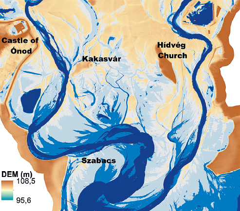
Bitva u Mohi roku 1241 představovala zásadní střet mezi Uherským královstvím a Mongoly postupujícími do Evropy. Nedávné výzkumy této bitvy zpřesnily naše chápání událostí spojených s touto konfrontací. Ačkoli tyto studie vycházejí ze společného badatelského základu, opírají se o heterogenní prostorová data, protože dosud neexistuje jednotná databáze GIS. To omezuje plné využití nástrojů, jako je historický GIS (HGIS), který by mohl tato různorodá data integrovat do jednotné, archeologicky orientované databáze a podpořit jejich analýzu a interpretaci. Tato studie představuje přístup založený na tvorbě detailního potenciálového modelu, jehož cílem je identifikovat pravděpodobnou polohu uherského tábora. Analýza propojuje archeologická, vojensko-historická a relevantní environmentální data, vážená metodou analytického hierarchického procesu (AHP), přičemž jejím výsledkem je potenciální mapa s rozlišením pět metrů. Zjištění přispívají k prostorově ukotvenější rekonstrukci bitvy a poskytují metodologický základ pro budoucí archeologický výzkum.
Stažení
Reference
Bánlaky, J. 1932: A Magyar nemzet hadtörténelme V. Budapest: Grill Károly Könyvkiadó vállalata.
Bellón Ruiz, J. P. – Rueda Galán, C. – Lechuga, M.A. – Ruiz Rodriques, A. – Molinos Molinos, M. 2016: Archaeological methodology applied to the analysis of battlefields and military camps of the Second Punic War. Quaternary International 435, 81–97. DOI: https://doi.org/10.1016/j.quaint.2016.01.021
Berend, N. 2013: At the Gate of Christendom: Jews, Muslims and ‘Pagans’ in Medieval Hungary, c. 1000–c. 1300. Cambridge: Cambridge University Press.
Bodnár, T. 2021: Raktárrevízióval kezdődött, a muhi csatával végződött. Available at: https://mnl.gov.hu/mnl/bazml/hirek/raktarrevizioval_kezdodott_a_muhi_csataval_vegzodott [accessed 19–11–2025]
Choudhury, S. – Basak, A. – Biswas, S. – Das, J. 2022: Flash Flood Susceptibility Mapping Using GIS–Based AHP Method. In: B. Pradhan et al. (eds.): Spatial Modelling of Flood Risk and Flood Hazards. Springer, 119–142. DOI: https://doi.org/10.1007/978-3-030-94544-2_8
Csoma, J. 1972: A Sajó hidrográfiája. In: Vízrajzi Atlasz Sorozat 13. Sajó. 1. Hidrográfia, geomorfológia. Budapest: VITUKI, 8–14.
Dobai, A. – Deák, T. – Gömöri, A. – Dobos, E. 2025: GIS–based spatial analysis of the Kakasvár site. Geosciences and Engineering 13(2), 127–142.
Dobai, A. – Dobos, E. 2022: Térinformatikai eljárások alkalmazása a régészeti kutatások támogatásához. In: N. P. Szabó – Z. Virág (eds.), Új eredmények a műszaki föld– és környezettudományban 2022, a Műszaki Földtudományi Kar konferencia kiadványa. Miskolc: Műszaki Földtudományi Kar, 96–106. Available at: https://mfk.uni-miskolc.hu/files/20006/MFK2022kiadvany_vegleges.pdf [accessed 19-11-2025].
Dobai, A. – Dobos, E. 2023: GIS a régészet szolgálatában: A Muhi–csata. In: Abrahi-Molnár, V. É. (ed.), Az elmélet és gyakorlat találkozása a térinformatikában XIV. Debrecen: Debrecen University Press, 360–361. Available at: https://giskonferencia.unideb.hu/arch/GIS_Konf_kotet_2023.pdf [accessed 19-11-2025].
Dobos, E. – Daroussin, J. 2005: The derivation of the Potential Drainage Density Index (PDD). In: Dobos et al., An SRTM–based procedure to delineate SOTER Terrain Units on 1:1 and 1:5 million scales 55. Luxembourg: Office of Official Publications of the European Communities, 40–51.
Dövényi, Z. (ed.) 2010: Magyarország kistájainak katasztere (Cadastral Map of the Microregions of Hungary). Budapest: MTA Földrajztudományi Kutató Intézet, 215–216.
Édes, V. 1858: Ónod vár. Vasárnapi Újság 16, 184–186. Available at: https://epa.oszk.hu/00000/00030/00216/datum05885/cim205891.htm [accessed: 14-04-2026]
ÉMVIZIG 2014: A TAKTA-rendszer szerencsi vasúti híd – Sajó-torkolat közötti szakaszának 08.NMT.08. tervszámú nagyvízi mederkezelési terve. Nagyvízi mederkezelési terv készítése a Sajó–Tarna vízrendszerére (Contract no. ÉM-VIZIG/Z1540370). Available at: https://www.emvizig.hu/eszak-magyarorszagi/kozerdeku/dokumentumok-letoltesek/nagyvizi-mederkezelesi-tervdokumentaciok [accessed 17-05-2026]
Engel, P. 2001: The Realm of St Stephen: A History of Medieval Hungary, 895–1526. London: I.B. Tauris. DOI: https://doi.org/10.5040/9780755699926
Eroglu, E. – Meral, A. 2021: Evaluation of flood risk analyses with AHP, Kriging, and weighted sum models: example of Çapakçur, Yeşilköy, and Yamaç microcatchments. Environmental Monitoring and Assessment 193, 505. DOI: https://doi.org/10.1007/s10661-021-09282-w
Fischl, K. P. – Pusztai, T. 2018: A dél–borsodi síkság bronzkori és középkori településstruktúrájának összehasonlítása. In: Mérai, D. et al. (eds.), Genius loci – Laszlovszky 60. Budapest: Archaeolingua, 82–88.
Foard, G. – Partida, T. 2018: The archaeology of medieval and early modern battlefields in Flanders. Journal of Conflict Archaeology 13, 12–36. DOI: https://doi.org/10.1080/15740773.2018.1551914
Gábris, Gy. 2022: A folyóvíz felszínalakító tevékenysége Magyarországon. 2nd revised edition. Budapest: ELTE Department of Physical Geography.
Greco, S. – Girvetz, E. H. – Larsen, E. – Mann, J. – Tuil, J. – Lowney, C. 2008: Relative elevation topographic surface modelling of a large alluvial river floodplain and applications for the study and management of riparian landscapes. Landscape Research 33, 461–486. DOI: https://doi.org/10.1080/01426390801949149
Gregory, I. N. – Ell, P. S. 2007: Historical GIS: Technologies, Methodologies and Scholarship. Cambridge: Cambridge University Press. DOI: https://doi.org/10.1017/CBO9780511493645
Győrffy, Gy. 1981: A tatárjárás emlékezete. Budapest: Magyar Helikon Kiadó.
Halperin, C. 1987: Russia and the Golden Horde: The Mongol Impact on Medieval Russian History. Bloomington: Indiana University Press. DOI: https://doi.org/10.2979/2859.0
Hewitt, C. M. 2016: Was the Battle of Hastings Really Fought on Battle Hill? A GIS Assessment. Historical Geography 44, 127–148.
Hodgkins, A. 2016: The battle of London (1554) – reconstructing a renaissance battlefield. Journal of Conflict Archaeology 11(2–3), 78–114. DOI: https://doi.org/10.1080/15740773.2017.1334327
Hungarian National Museum Archaeology Database. Available at: https://archeodatabase.hnm.hu [accessed 25-11-2025].
Jackson, P. 2017: The Mongols and the Islamic World: From Conquest to Conversion. New Haven – London: Yale University Press. DOI: https://doi.org/10.12987/yale/9780300125337.001.0001
Kiss, P. 2018: Térinformatikai módszerek alkalmazása a nagyvízi mederkezelési és a folyógazdálkodási tervek készítése során a Tisza folyó Tokaj–Tiszaújváros közötti szakaszán. Budapest: Budapest University of Technology and Economics. Unpublished MSc thesis.
Krąpiec, M. – Piekalski, J. 2019: Dendrochronology vs. dating of complex stratigraphic sequences: The example of medieval Wrocław. Archeologické rozhledy 71, 309–326. DOI: https://doi.org/10.35686/AR.2019.12
Kristó, Gy. 2007: Magyarország története 895–1301. 226. Budapest: Osiris
Laszlovszky, J. – Kubinyi, A. – Szabó, J. – Takács, M. 2016a: The Medieval Hungarian Settlement System and the Mongol Invasion. In: J. Laszlovszky et al. (eds.), The Mongol Invasion of Europe and Its Consequences. Budapest: Central European University Press, , 55–89.
Laszlovszky, J. – Nagy, B. 2023: Mederváltozás és kontinuitás a Sajó folyó középkori átkelőhelyeinél: A Muhi csatatér kutatásához kapcsolódó földrajzi és régészeti vizsgálatok. 156, 943–962.
Laszlovszky, J. – Pow, S. – Pusztai, T. 2016b: A muhi csata és az 1241–es tatárjárás – új régészeti és történeti megközelítések. Magyar Régészet 5, 27–36
Laszlovszky, J. – Rácz, T. 2020: Fémkeresős kutatások a Muhi csatatéren: Közösségi régészet, hadszínterek vizsgálata és a kapcsolódó módszertani kérdések. Magyar Régészet 9, 70–80. DOI: https://doi.org/10.36245/mr.2020.4.7
Malczewski, J. 1999: GIS and Multicriteria Decision Analysis 414-420. New York: John Wiley & Sons.
Markku, N. 2023: Size and conformation of Medieval horses of Northwestern Europe based on osteoarchaeological evidence. Conference paper. The 28th EAA Annual Meeting in Budapest 2022.
May, T. 2012: The Mongol Conquests in World History. London: Reaktion Books.
Mohamed, M. A. 2020: Classification of Landforms for Digital Soil Mapping in Urban Areas Using LiDAR Data Derived Terrain Attributes: A Case Study from Berlin, Germany. Land 9, 319. DOI: https://doi.org/10.3390/land9090319
Négyesi, L. 1997: A Muhi csata 1241 április 11. Hadtörténeti Közlemények, 296–310. Available at: https://epa.oszk.hu/00000/00018/00001/pdf/04negyesi.pdf [accessed 25-11-2025].
Négyesi, L. 2024: A muhi csatával kapcsolatos lokalizációs kérdések. Ephemeris Hungarologica 1, 64–76. DOI: https://doi.org/10.53644/EH.2024.1.64
Ónod Settlement Development Plan 2014: Ónod településszerkezeti terv a külterületre. Available at: http://onod.hu/Rendezesi_terv/Regi/Onod_kulterulet.pdf [accessed 25-11-2025].
Piekalski, J. 2023: Mongol invasion and the destruction of Wrocław in April 1241: The problem of interpreting archaeological sources. Archaeologia Historica Polona 31, 109–129. DOI: https://doi.org/10.12775/AHP.2023.004
Pow, S. 2022: The Mongol invasions of Europe. In: T. May – M. Hope (eds.), The Mongol World. London: Routledge, 183–195. DOI: https://doi.org/10.4324/9781315165172-15
Pusztai, T. 2014: Buzogánnyal, tarsollyal és késtok–merevítővel eltemetett halott a muhi csatából. In: Sz. Rosta – Gy. V. Székely (eds.), “Carmen miserabile” A tatárjárás magyarországi emlékei. Tanulmányok Pálóczi Horváth András 70. születésnapja tiszteletére. Kecskemét: Kecskeméti Katona József Múzeum, 141–150.
Rybczyk, J. M. – Callaway, J. C. – Day, J. W. Jr. 1998: A relative elevation model for a subsiding coastal forested wetland receiving wastewater effluent. Ecological Modelling 112, 23–44. DOI: https://doi.org/10.1016/S0304-3800(98)00125-2
Salomon, V. A. P. – Gomes, L. F. A. M. 2024: Consistency Improvement in the Analytic Hierarchy Process. Mathematics 12, 828. DOI: https://doi.org/10.3390/math12060828
Sarris, A. 2024: The polymorphism of archaeological GIS. In: Unfolding the archaeological dimensions of GIS. Journal of Greek Archaeology 9, 9–19. DOI: https://doi.org/10.32028/jga.v9i.2731
P. Szabó, S. 2018: A muhi csata és a tatárjárás középkori kínai nyelvű források fényében. Hadtörténelmi Közlemények 131, 259–286.
P. Szabó, S. 2022: Kínai nyelvű mongol kőtáblafelirat a muhi csatáról. Hadtudomány 32, 112–123. DOI: https://doi.org/10.17047/HADTUD.2022.32.2.112
Veszprémy, L. 1994: Újabb szempontok a tatárjárás történetéhez. Iskolakultúra 4(15–16), 28–35.
Williams, T. 2015: Landscape and warfare in Anglo–Saxon England and the Viking campaign of 1006. Early Medieval Europe 23, 329–359. DOI: https://doi.org/10.1111/emed.12107
Wolf, M. 2014: Régészeti adatok a muhi csata történetéhez. In: Sz. Rosta – Gy. V. Székely (eds.), “Carmen miserabile” A tatárjárás magyarországi emlékei. Tanulmányok Pálóczi Horváth András 70. születésnapja tiszteletére. Kecskemét: Kecskeméti Katona József Múzeum, 69–80.
Wolf, M. 2018: Régészeti adatok a tatárjárás történetéhez. Archaeológiai Értesítõ 143, 138–140. DOI: https://doi.org/10.1556/0208.2018.143.7
Stahování
Další soubory
Publikováno
Jak citovat
Licence
Copyright (c) 2026 András Dobai, András Gömöri, Tamás Deák, Endre Dobos

Tato práce je licencována pod Mezinárodní licencí Creative Commons Attribution 4.0 .